
- Details
Today the EOXPOSURE coordinator, Fabio Dell'Acqua, is in Brussels to attend the H2020 RISE coordinators' day, an initiative to inform coordinators of RISE project about how to manage the project, relationships with REA, and how to report and communicate about the projects.
- Details
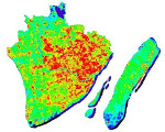
An increasing awareness is emerging that, although extremely useful in a large pool of applications, space-based sensing, alone, is not sufficient to reach the desired accuracy, reliability, precision, and especially completeness of data requested in some cases.
In the context of risk assessment, where missing details can have a great impact on the accuracy of projected disaster scenarios, it is important to guarantee a reasonable completeness of the data kit; to meet such an ambitious goal, consistent and operational monitoring systems are needed to integrate spaceborne acquisitions at a variety of spatial and temporal resolutions.
- Details
Following the success of the first Concurrent Engineering Workshop held in September 2016, the ESA Academy’s Training and Learning Programme is again offering university students the opportunity to learn how ESA assesses technical and financial feasibility of space missions.
ESA’s Education Office sought 44 talented and motivated university students from across all ESA Member and Associate States with an engineering or physics background to take part in one of the two upcoming Concurrent Engineering Workshops which will take place on 14-17 March and on 9-12 May 2017.
- Details
Today, Friday the 20th of January 2017, at 11.00 am, in the Seminar Room at floor D, Professor Devis Tuia, SNSF Professor at the University of Zurich, gave a seminar on “Domain Adaptation in Remote Sensing Image Classification: Making the Most out of your Data”.
This is he fourth talk of the series “Distinguished Talks – Insignia Colloquia” took place, realized thanks to the IEEE student association PESB (Pavia Engineering Student Branch) and a financial contribution from the "Permanent Student Board" at the University of Pavia.
- Details
Daniele De Vecchi, who has just completed his PhD at the Laboratory of Telecommunications and Remote Sensing of the Department of Industrial and Information Engineering, University of Pavia, in the past year had already collected quite a few medals in the field of Apps for mobile terminals that use and manage data acquired by Earth observation satellites.
In fact, in April he was among the winners of the MyGeoss competitive tender, organized by the Joint Research Centre of the European Union, with the "Cloopsy" App proposal for land cover validation.