H2020 MSCA-RISE "EOXPOSURE" (2016-2020)
The goal of the EOxposure project is to build tools to quantify the exposure of population and economic assets to multiple risks using novel information layers from current and future Earth Observation (EO) missions, as well as the growing sensor web on the ground.
http://www.h2020-eoxposure.eu/
“INROAD: Fostering ERC talents” for excellence in ERC project design (2017-2020)

Sponsored by University of Pavia and Fondazione Cariplo, INROAd fund has been awarded to Andrea Marinoni for supporting the preparation, design and editing of an ERC Starting Grant project. Andrea Marinoni has then built up an ERC proposal named “Flexible multidimensional information geometry for multihazard risk assessment (FLEMING)”, which aims at developing a brand new framework for accurate characterization of large-scale heterogeneous datasets with low coherence on the acquisition strategies, especially applied to the description and prediction of natural hazards.
http://inroad.unipv.eu/
PULSE (2016-2019): Participatory Urban Living for Sustainable Environments

PULSE is a new international project funded by the European Commission (Horizon 2020) to undertake research and innovation in cities in Europe, the United States and Asia. The project began at the close 2016 and will continue for three years. The PULSE project will combine a unique Big Data ecosystem with innovative approaches to Big Data analytics. The Project will be the first to build an integrated systems-of-systems approach to public health challenges in cities, to transform public health from a reactive to a predictive system, focused on both risk and resilience. TLC&RS Lab is in charge for providing air quality maps from remote sensing data processing for daily monitoring of atmospheric pollution on five test sites.
http://www.pulseproject.info
FP7 SENSUM (2013-2014)
SENSUM was aimed at delivering innovative methodologies and software tools for dynamic, multi-resolution monitoring of pre-disaster vulnerability and preparedness and post-disaster recovery planning and monitoring, based on current and future space-based products and a novel approach to in-situ observation for data rich and data poor countries.
http://www.sensum-project.eu/
FP7 MARSITE (2012-2015)
 The MARSITE project aimed to coordinating research groups with different scientific skills (from seismology to engineering to gas geochemistry) in a comprehensive monitoring activity developed both in the Marmara Sea and in the surrounding urban and country areas. The project coordinated initiatives to collect multidisciplinary data, to be shared, interpreted and merged in consistent theoretical and practical models suitable for the implementation of good practices to move the necessary information to the end users.
http://marsite.eu/
PRIN 2009 (2011-2013): Post-processing algorithms for high-resolution radar imaging
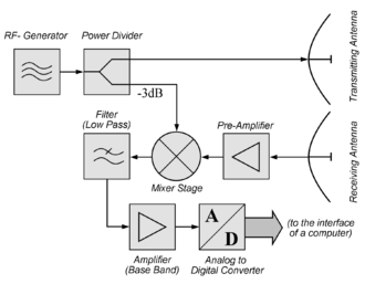 In order to achieve full exploitation of the data recorded by the radar system developed during the overarching research, novel methodologies are required. They have to be designed in such a way that they are suitable to extract information from the original data set. In a first phase, the system design phase, these methodologies proved useful to define the choices to be implemented in the realisation phase. Digital Signal Processing (DSP) issues are extremely important from the definition of the system architecture and limitations.
More specifically, during this research we used and adapted to automotive radars some techniques originally designed for civil and military tracking radar applications, naturally taking into account the finer spatial resolution but with lower quality (SNR). Target identification and tracking, target recognition and classification, target analysis, were all considered and implemented in the proposed system, with a specific aim at close-range targets.
GEM-IDCT (2010-2013): Global Earthquake Model - Inventory Data Capture Tools
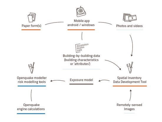 The Inventory Data Capture Tools (IDCT) project is one of GEM’s (Global Earthquake Model) Risk Global Component. The project addresses the inventory and damage data development needs of the GEM user community, in developing input to the Global Exposure and Global Consequences databases that underpin GEM's seismic risk module.
The project aimed to providing a fully operational, flexible and integrated suite of tools, protocols and guidelines that are scientifically-founded, yet straightforward to use.
https://storage.globalquakemodel.org/what/physical-integrated-risk/inventory-capture-tools/
EU FP 7 SAFER (2009-2011): GMES Emergency Fast Track Service
SAFER aimed at implementing preoperational versions of the Emergency Response Core Service. SAFER reinforced the European capacity to respond to emergency situations: fires, floods, earthquakes, volcanic eruptions, landslides, humanitarian crisis. The main goal was the upgrade of the core service and the validation of its performance with 2 priorities: the first priority was the short term improvement of response when crisis occurs, with the rapid mapping capacity after disastrous events, including the relevant preparatory services (reference maps).
https://cordis.europa.eu/project/rcn/89681_en.html